Avalanche Outlook for Saturday & Sunday
Click here to see the complete danger scale
Issued 1/17/14 @ 11pm
The Lowdown:
Extreme winds (gusts to 93mph at Glen Alps and 92mph at Arctic Valley Friday), warm temperatures (above freezing to at least 2500′ Friday), and liquid precipitation (rain to at least 1500′ Friday) have all been sources of shock to the Front Range and Eagle River area snowpack in the past 24 hours. Avalanche danger is expected to be at the more dangerous end of “considerable” Saturday, decreasing to the less dangerous end of “considerable” Sunday.
Concerns:
Click here to learn more about this type of avalanche problem and how to manage it
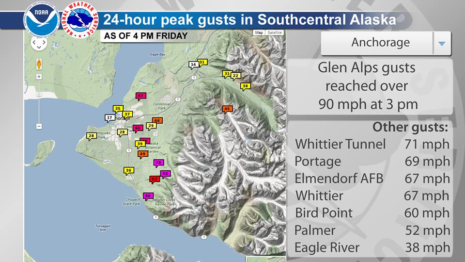
Winds, predominantly from the southeast have been raging since Thursday night. Thursday morning’s snowfall provided ample loose snow, which has likely been transported near and far forming wind slabs of varying natures. Naturally occurring wind slab avalanches likely occurred Friday throughout the Front Range and Eagle River area Chugach, with extreme winds gusting up to 93mph at Glen Alps and 92mph at Arctic Valley – where they gusted in the 80s for several hours. Here’s a look at winds around Anchorage from the laudable Anchorage NWS office:
Winds are expected to remain strong to extreme through the weekend. Expect dangerous wind slabs to exist in many areas and persist through the weekend.
Click here to learn more about this type of avalanche problem and how to manage it
Extreme winds, warm temperatures, and liquid precipitation have all further stressed the persistent slab problem. Large and very dangerous persistent slabs may have failed naturally on Friday in some areas. Others may fail naturally or remain on the brink of failure through the weekend, being extremely susceptible to human triggers.
Small to medium sized wet avalanches likely failed naturally on Friday below 2500′. While this problem should be the first to decrease through the weekend, wet avalanches at the lower to mid elevations may fail naturally again on Saturday and will remain susceptible to human triggering. Wet slab avalanches and loose wet avalanches remain a possibility through the weekend at lower to mid elevations.
Mountain Weather:
Saturday: Cloudy with chances for up to several inches of wet to moist snow accumulation at higher elevations increasing in the afternoon. Temperatures in the upper 20s to lower 30s with extreme southeast winds decreasing to strong later in the day.
Sunday: Chances for some sunshine increasing. Strong southeast winds and temperatures in the 20s.


