
Avalanche Danger Forecast
Issued Tuesday, February 9, 2021 at 10:30am for the greater Anchorage area Western Chugach Mountains (i.e. Chugach State Park). View map of primary forecast area here.
Tuesday: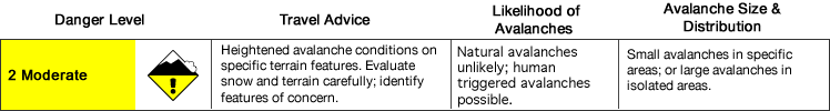
Wednesday-Thursday: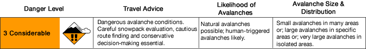
Avalanche danger will rise from moderate Tuesday to considerable Wednesday due to increasing wind and the chance for light snowfall.
A few inches of new snow are possible Tuesday night into Wednesday with likelihood and amount increasing in southeastern areas of the park. Wind will also be stronger in southern and eastern areas of the park.
Small wind slabs and small to medium sized persistent slabs are the primary avalanche problems.
Mountain Weather:
Tuesday: increasing clouds, alpine temps in the lower teens, light to moderate east to south wind
Wednesday: cloudy with a chance of light snow, alpine temps in upper teens to low 20s, moderate to strong east to south wind
Thursday: cloudy, alpine temps in the upper teens to low 20s, moderate to strong east to south wind (decreasing later in the day)
Discussion:
Recent cold temperatures have not been beneficial for the snowpack and have exacerbated the faceting process, especially near the ground and at the surface.
Localized moderate to strong northerly winds accompanying the clear and cold weather recently created wind slabs on leeward upper elevation terrain. While now old, these wind slabs are still poorly bonded to their underlying snow surface. We found this to be the case yesterday in the Front Range on multiple aspects, although poor bonding was especially pronounced on shadier and colder northerly aspects.
Additionally, we found the snow surface to be heavily faceted and facets near the ground and around rocks especially large and weak. Impressive facet chains, advanced facets, and depth hoar were observed at the base of the snowpack in rocky upper elevation areas on both solar and shady aspects.
Despite no significant weather recently (other than localized north winds capable of wind loading isolated upper elevation terrain), we backed off of skiing our original objective after finding old wind slabs to still be anomalously poorly bonded. This poor bonding is a result of the periods of cold weather in recent weeks faceting near surface snow and creating a persistent weak layer that slabs from minor snowfall and localized outflow wind loading events have not bonded well to.
With a few inches of new snow possible Tuesday night into Wednesday, and wind loading and the development of new wind slabs through this forecast period certain, avalanche danger is expected to increase to considerable.
While large avalanches are not expected, small to medium sized avalanches are likely to be human triggered and naturally triggered avalanches are possible. It will be important to be mindful of steep terrain above you (even if you’re on flat terrain), as many popular trails in Chugach State Park cross potentially dangerous avalanche paths.
Strong wind this forecast period may trigger upper elevation avalanches that run into the mid elevations (and possibly even lower elevations) and cross trails like Powerline from Glen Alps, Falls Creek on Turnagain Arm, and the trail to Penguin Ridge.
Localized strong northerly wind accompanying the periods of cold and clear weather in recent weeks primarily affected terrain closer to Knik Arm with potentially dangerous wind loading (and was responsible for the three avalanche fatalities on Bear Mountain in the Peters Creek area on February 2). Offshore flow and outflow northerly wind accompanying high pressure and clearing skies affects these western and northwestern areas of the park the most significantly.
The opposite is the case when we have onshore flow with stormy weather affecting the Gulf of Alaska and Prince William Sound: the mountains near Knik Arm are relatively sheltered from southerly and easterly wind while terrain near Turnagain Arm and deeper in the mountains to the east is more severely affected. This forecast period, flow shifts to onshore from the Gulf and PWS and wind will more significantly affect Turnagain Arm and southeastern areas of the park.
Avalanche Problems:
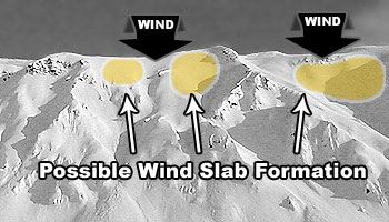
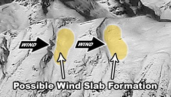
 Wind slabs (up to D2 in size) are likely above 2500′ on leeward terrain. While these are likely to initiate from terrain steeper than 35º in the upper elevations, they may run into much lower angle terrain in the mid to lower elevations.
While wind will primarily be from the east to south through this forecast period, the terrain of the forecast area channels winds in varying directions. It’s important to pay close attention to wind scouring and loading patterns in order to better understand where potentially reactive wind slabs may exist in the specific area you’re visiting.
Active wind loading, recent avalanches, and shooting cracks are red flag indicators of wind slab danger. Wind slabs are most likely to exist below corniced areas and along the lee sides of ridges and cross-loaded features like gullies:
Relatively densely-packed (firm and “punchier” feeling) snow and pockets of deeper snow (especially with a bulbous or fat appearance) are indicators of wind slabs. If you look closely at the snow surface, you may be able to distinguish where wind slabs exist due to the snow having a more textured, densely-packed, consolidated, and/or cohesive appearance.
Pole probing and hand pits are a quick and effective means of assessing this problem as you travel. Use pole probing to quickly feel out areas of denser, wind-packed snow overlying looser and weaker snow. Use hand pits to quickly assess how near-surface layers of snow are bonded.
Digging a snowpit and conducting a compression test and/or extended column test will provide an even better assessment of bonding and instability before you travel on terrain of consequence.
You can also assess wind slab instability via safer “test slopes” that are representative of higher consequence terrain.

Persistent slabs up to D2.5 in size are possible on all aspects above 2500′. Again, while these are likely to initiate from terrain steeper than 35º in the upper elevations they may run into much lower angle terrain in the mid to lower elevations.
Be on the lookout for red flag warnings of persistent slab danger: recent avalanches, collapsing (aka “whumphing“), and shooting cracks.
While we’ve been reiterating this avalanche problem as a lower probability but higher consequence one in recent weeks, both the probability and consequences of getting caught in a persistent slab increase this forecast period.
Persistent slabs triggered this forecast period may be hard slabs that break deeper down in the snowpack and have a tendency to release above and around a human trigger (rather than at the trigger’s feet) which can make escape difficult. Hard slab avalanche debris is also more likely to cause trauma than debris from soft slabs.
Diverse and widespread persistent weak layers exist in the snowpack. Faceted snow exists above and below crusts in some areas, sandwiched between wind packed layers in many areas, and a basal weak layer of advanced facets and depth hoar is widespread. Surface hoar has been observed in some areas, and it may survive the wind in lower elevation and isolated mid elevation locations. While dangerous terrain where buried surface hoar may be buried intact by new snow is very limited, keep it in mind if you’re traveling around lower to mid elevation terrains traps.
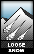 Dry loose snow avalanches are possible above 3000′ on steep terrain (38º+) across all aspects. Naturally triggered spindrift and human triggered sluffs are possible in the upper elevations.
While these relatively small avalanches (D1) aren’t much of a concern in regard to burial, they do have the potential to cause a fall or loss of control. While not likely, it’s possible that a loose snow avalanche could trigger a larger wind or persistent slab as it descends a slope and gains mass.
Don’t let a loose snow avalanche catch you off guard. Manage your sluff if descending steep terrain via ski or snowboard. If it happens to be windy and you’re climbing steep and/or exposed terrain, be mindful of the potential for heavy spindrift that could knock you off your feet and take you for a ride.
![]()
Cornices have grown large in areas above 3000′. They may become more prone to failure this forecast period due to strong wind.
Give the edge of overhanging cornices a wide berth and don’t approach the edge of a ridge line to look down slope, unless you’re sure it’s not corniced. Cornices can break off further back than expected (even beyond the true edge of the mountain ridge beneath the snow surface).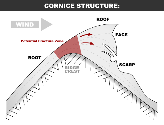
Terrain management is always the best way to deal with avalanche problems: eliminate or reduce your exposure terrain capable of producing an avalanche. Before traveling on or under terrain that has the potential to avalanche think about the consequences and have a plan (to escape the avalanche, for re-grouping, and rescue).
Always be mindful of terrain traps that can make even a small avalanche deadly.
Click the hyperlinks and icons to learn more.