
Avalanche Danger Forecast
Issued Thursday, February 18, 2021 at noon for the greater Anchorage area Western Chugach Mountains (i.e. Chugach State Park). View map of primary forecast area here.
Friday:
Saturday-Sunday:
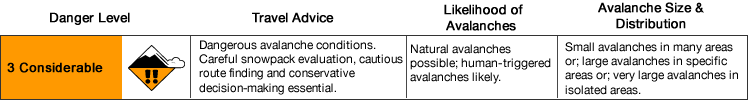
Avalanche danger will increase to considerable in some areas Friday due to strong outflow northerly winds loading leeward terrain with Thursday’s snowfall.
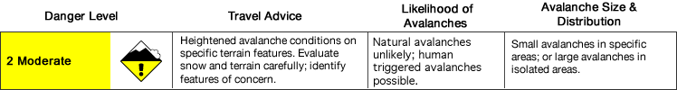
Decreasing danger is expected Saturday and Sunday as winds lessen and generally quiet weather is expected.
Small to medium-sized natural wind slab and persistent slab avalanches are possible in the upper elevations Friday. Don’t be fooled by the clearing skies and sunny weather: winds Friday will bring the most significant spike in avalanche danger this forecast period. Beware of steep terrain above you where a natural avalanche might occur. It’s possible that a natural avalanche triggered in the upper elevations might run into flatter, lower elevation terrain and cross a trail (e.g. Penguin Ridge and Falls Creek from Turnagain Arm, Powerline from Glen Alps along the north side of the Flattop-Flaketop ridge, Upper South Fork Eagle River near Eagle Lake). Make sure you know how to identify avalanche terrain, and don’t linger under avalanche paths that cross trails.
Human triggered wind and persistent slab avalanches, loose dry avalanches, and cornice falls will be possible through the weekend.
Mountain Weather:
Friday: decreasing clouds, alpine temps in the single digits to low teens, moderate northerly wind (possibly strong in upper elevations areas, especially near Knik Arm and on the west side of the Front Range where terrain is more exposed to NW outflow wind )
Saturday: sunny, alpine temps in the single digits to teens, light to moderate wind (primarily northerly)
Sunday: sunny, alpine temps in the single digits to teens, light to moderate wind (primarily northerly)
Discussion:
Tuesday’s snow event brought more snow to town than the mountains. What was generally a couple inches of light and dry powder that accumulated in the mountains was quickly affected by moderate, and then strong, winds that developed shortly after snowfall stopped. Tuesday’s snow was not enough to provide for the refresh the mountains needed to enhance riding quality. There was a brief window of decent riding Tuesday afternoon in localized areas on leeward terrain where new snow was “blown in” and deeper. Later Tuesday, strong winds returned the mountains to a state of generally poor riding conditions much like prior to the snow event.
The upper elevations received a trickle of more snow Tuesday night into Wednesday, but this snow came in warm and temperatures increased further during the day. On solar aspects glopping was an issue and there were small human triggered roller balls. On the bright side, the warm temperatures and solar radiation did not seem to destabilize the snowpack beyond slight surface instabilities and improved the temperature gradient for bonding and stabilization (especially of buried near surface facets that developed from cold weather earlier this month).
Thursday’s snowfall initially seemed to again be bringing more snow to town than the mountains, especially as the National Weather Service reported the heaviest band of precipitation being oriented to our west from Kenai to Willow, but by midday snotels and webcams suggest snowfall in the mountains may be increasing. Let’s hope for at least a few inches, as it will take at least that much to improve riding conditions.
Going into the weekend, skies will be clearing with increasing sunshine. However, this will bring moderate to strong northerly outflow winds that will create for the most dangerous avalanche conditions of this forecast period on Friday. Natural avalanches will be possible in some upper elevation leeward areas, and human triggered avalanches likely.
Again, don’t be fooled by the clearing skies and sunny weather Friday: beware of steep terrain above you where a natural avalanche might occur even if you’re on flat terrain. It’s possible that a natural avalanche triggered in the upper elevations might run into flatter, lower elevation terrain and cross a trail (e.g. Penguin Ridge and Falls Creek from Turnagain Arm, Powerline from Glen Alps along the north side of the Flattop-Flaketop ridge, Upper South Fork Eagle River near Eagle Lake). Make sure you know how to identify avalanche terrain, and don’t linger under avalanche paths that cross trails.
Danger is expected to decrease Saturday and Sunday, but human triggered avalanches will remain possible.
Avalanche Problems:
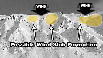
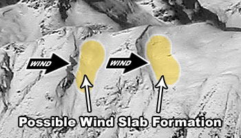
 Both natural and human triggered wind slabs up to D2 in size are possible (human triggered likely in some areas Friday) above 2500′ on leeward terrain steeper than 35º.
Strong northerly winds Friday will build fresh wind slabs from Thursday’s snowfall. Wind slab danger is expected to decrease Saturday and Sunday, but human triggered wind slabs will remain possible as localized winds may continue to build small, fresh wind slabs in the upper elevations through the weekend.
Active wind loading, recent avalanches, and shooting cracks are red flag indicators of wind slab danger. Wind slabs are most likely to exist below corniced areas and along the lee sides of ridges and cross-loaded features like gullies:
Relatively densely-packed (firm and “punchier” feeling) snow and pockets of deeper snow (especially with a bulbous or fat appearance) are indicators of wind slabs. If you look closely at the snow surface you may be able to distinguish where wind slabs exist due to the snow having a more textured, densely-packed, consolidated, cohesive, and/or striated appearance. Be especially wary of (and avoid) steep, convex, and/or unsupported wind loaded terrain features.
Pole probing and hand pits are a quick and effective means of assessing this problem as you travel. Use pole probing to quickly feel out areas of denser, wind-packed snow overlying looser and weaker snow. Use hand pits to quickly assess how near-surface layers of snow are bonded.
Digging a snowpit and conducting a compression test and/or extended column test will provide an even better assessment of bonding and instability before you travel on terrain of consequence.
You can also assess wind slab instability via safer “test slopes” that are representative of higher consequence terrain.

Both natural and human triggered persistent slabs up to D2.5 in size are possible above 2500′ on terrain steeper than 35º.
While persistent slabs may exist on all aspects, expect the problem to be the most pronounced on recently wind loaded terrain (where buried persistent weak layers may be “stressed” and haven’t adjusted to the recently added load) and shadier and colder northerly aspects (where the temperature gradient hasn’t facilitated bonding and stabilization of buried persistent weak layers).
The persistent slab problem is lower probability, but potentially much higher consequence, than the wind slab problem. Persistent slabs triggered this forecast period may be hard slabs that break deeper down in the snowpack and release above and around a human trigger (rather than at the trigger’s feet) which can make escape difficult. Hard slab avalanche debris is also more likely to cause trauma than debris from soft slabs.
Be on the lookout for red flag warnings of persistent slab danger: recent avalanches, collapsing (aka “whumphing“), and shooting cracks.
Diverse and widespread persistent weak layers exist in the snowpack. Faceted snow exists above and below crusts in some areas, sandwiched between wind packed layers in many areas, and a basal weak layer of advanced facets and depth hoar is widespread. Surface hoar may also exist in isolated areas, although dangerous terrain where it’s been buried intact is likely very limited. That said, keep it in mind if you’re traveling around mid elevation terrain traps.
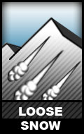 Dry loose snow avalanches (human triggered sluffing and naturally triggered spindrift) are possible above 3000′ on steep terrain (38º+) across all aspects.
While these relatively small avalanches (D1) aren’t much of a concern in regard to burial, they do have the potential to cause a fall or loss of control. While not likely, it’s possible that a loose snow avalanche could trigger a larger wind or persistent slab as it descends a slope.
Don’t let a loose snow avalanche catch you off guard. Manage your sluff if descending via ski or snowboard steep and wind-sheltered terrain with loose and uncohesive snow. If it’s windy and you’re climbing steep and/or exposed terrain, be mindful of the potential for heavy spindrift that could knock you off your feet and take you for a (potentially deadly) ride.
![]()
Both natural and human triggered cornice falls are possible. Cornices are large and overhanging in some areas above 3000′. New snow Thursday followed by strong wind Friday will make them more prone to failure and falling.
Give cornices a wide berth and don’t approach the edge of a ridge to look down slope unless you’re sure it’s not corniced. Cornices can break off further back than expected (even beyond the true edge of the mountain ridge beneath the snow surface). In addition to the danger of taking a nasty fall due to a collapsing cornice, a falling cornice may “bomb” the slope it lands on and trigger an avalanche.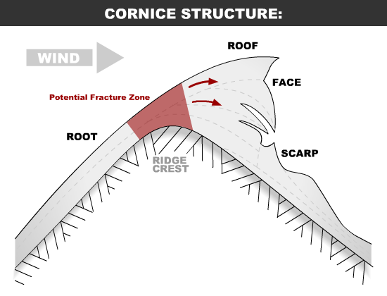
Terrain management is always the best way to deal with avalanche problems: eliminate or reduce your exposure to terrain capable of producing an avalanche. Before traveling on or under terrain that has the potential to avalanche think about the consequences and have a plan (to escape the avalanche, for re-grouping, and rescue).
Always be mindful of terrain traps that can make even a small avalanche deadly.
Click the hyperlinks and icons to learn more.
Please let us know what you’re seeing by tagging us on Instagram @anchorage_avalanche_center, submitting an observation, sending an email to info@anchorageavalanchecenter.org, or via FaceBook message. All observations help us provide a better forecast product (no matter how basic). We can keep your observation confidential, and only use the information to inform forecast products.