
Avalanche Danger Forecast
Issued Wednesday, December 2, 2020 at 3pm for the greater Anchorage area Western Chugach Mountains (i.e. Chugach State Park):
Wednesday: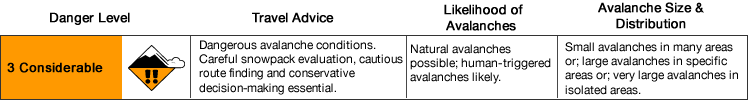
Thursday, Friday, & Saturday: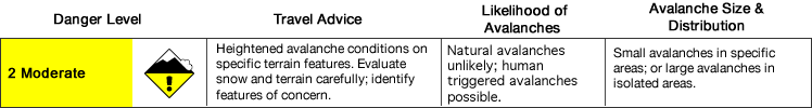
A few to several inches of new snow (even more in eastern, and especially southeastern, areas of the park) combined with strong winds Tuesday into Wednesday have increased avalanche danger. Avalanche danger is expected to decrease Thursday through Saturday as skies clear, winds become lighter, and temperatures drop.
That said, don’t underestimate moderate avalanche danger (especially during the early season). Dangerous human triggered avalanches remain possible through this forecast period.
Avalanche Problems:

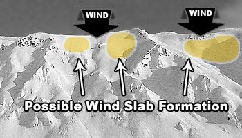
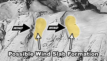
Natural (Wednesday only) and human triggered wind slabs up to D2 in size are possible on leeward (primarily west through north) aspects above 2500′ where the terrain is steeper than 30º. Wind slab danger is expected to decrease Thursday through Saturday as these slabs have time to bond and stabilize.
A little new snow in some areas earlier this week combined with a few to several inches of new snow Wednesday (more in eastern, and especially southeastern, zones) will be wind-loaded onto leeward terrain by moderate to strong winds Tuesday through Wednesday. Expect the most likely areas for potentially dangerous wind slabs to be along the lee sides of ridges and cross-loaded features (like gullies).
Recent avalanches, shooting cracks, hollow and/or punchy feeling snow, and pockets of deeper snow are all indicators of wind slab development. Also, expect wind slabs below and along corniced areas. Pole probing and hand pits are a quick and effective means of assessing this problem as you travel. Digging a snowpit and conducting a compression test and/or extended column test will give you an even better assessment before you commit to terrain of consequence.

Natural (Wednesday only) and human triggered persistent slabs up to D2.5 in size are possible on all aspects (but especially recently loaded and stressed northerly aspects with weaker snow) above 2500′ where the terrain is steeper than 35º.
Persistent slab danger is expected to decrease Thursday through Saturday, but this relatively unpredictable problem will persist through the forecast period. While such slabs are expected to become more stubborn to trigger over time, they may exhibit especially dangerous hard slab characteristics.
New snow and wind loading will stress existing persistent weak layers, which are diverse and widespread. Faceted snow exists above and below a melt-freeze crust in some areas, sandwiched between windpacked layers in many areas, and a basal weak layer of advanced facets and depth hoar is widespread.
In addition to red flags of persistent slab danger like recent avalanches, shooting cracks, and collapsing (aka “whumphing“); digging a snowpit and conducting an extended column test will give you a better idea of how this problem is manifesting where you intend to recreate.
Be especially wary of areas with more snow that may harbor larger slabs and produce larger and more dangerous avalanches.
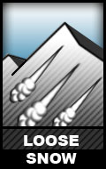
Natural and human-triggered dry, loose snow avalanches (aka “sluffs) are possible on wind-sheltered terrain above 3000′ where the terrain is steeper than 38º.
While these avalanches will be relatively small (D1), they do have the potential to cause a fall or loss of control and build up mass that “steps down” and triggers a larger slab avalanche.
Don’t let a small sluff catch you off guard, especially if you’re above exposed terrain. Rather than just “diving in;” it’s possible to intentionally trigger a sluff at your feet, watch it descend, and see how the snow below reacts.
Before traveling on, through, or under terrain that has the potential to avalanche; think about the consequences and have a plan (to escape the avalanche, for re-grouping, and rescue).
Avoid terrains traps!
Click the hyperlinks and icons to learn more.