
Springtime Avalanche Outlook
We will provide updates as warranted by conditions.
This is a regional backcountry avalanche forecast for the Western Chugach Mountains of Chugach State Park. It is provided pro bono by a local avalanche professional, is based on limited field data for a large area, and is meant to be used only as a general baseline for recreationists’ personal and specific assessment in the field. The Anchorage Avalanche Center and associates assume no responsibility or liability for the use of this information. Anyone using this information needs to be formally educated in regard to avalanches and backcountry travel. Please encourage statewide investment in high quality outdoor and environmental education via K-12 public schools, as this is the best way to ensure all Alaskans are “avy savvy.”
Click the hyperlinks and icons for further learning.
This is a springtime avalanche forecast for April 17-19, 2020.
Dangerous avalanche conditions exist: both natural and human triggered avalanches are likely with widespread small avalanches (D1), localized large avalanches (D2), and isolated very large avalanches (D3)! If you recreate in the mountains in the coming days make sure you know how to identify and avoid potentially dangerous avalanche terrain. This includes being aware of overhead avalanche danger even if you’re on flat ( and maybe even snow-free) terrain, as many popular trails in Chugach State Park are exposed to avalanche paths (e.g. Penguin Ridge, Indian Creek, Falls Creek, Powerline Trail, Little O’Malley gully, the last ~1.5 mile of South Fork Eagle River before the lakes).
Considering the COVID-19 public health crisis, dangerous avalanche conditions, and generally bad snow conditions (i.e. isothermal snow making for inefficient travel and injury-prone descents); we do not recommend recreation in avalanche terrain during this forecast period. The aforementioned factors will limit and/or complicate search and rescue.
If you are determined to get out in the mountains during these dangerous conditions, it will be especially important to practice safe travel protocols and effective terrain management to minimize exposure to potentially dangerous avalanche terrain and reduce the consequences if an avalanche is triggered. Be mindful of terrain traps that could cause debris to pile up more deeply, and exposed terrain where a fall or loss of control due to even a small avalanche could lead to significant trauma.
We recommend patiently awaiting better weather, snow, and avalanche conditions while pursuing other forms of recreation away from mountainous avalanche terrain. It’s still likely that conditions will turn around before the end of the ski season, the snowpack returns to a melt-freeze (i.e. “corn”) cycle, stability improves, and the mid to upper elevations get refreshes of spring powder.
Avalanche danger is considerable (trending towards high), and conditions are expected to remain dangerous through the forecast period of Friday-Sunday.
Above freezing temperatures and rain have been reaching the upper elevations recently, and are expected to continue to reach up to at least 4500′ through the forecast period. In addition, temperatures have been above freezing overnight to at least 4000′ in some areas. These factors will continue to weaken the snowpack and increase wet avalanche danger.
Avalanche danger will remain elevated until temperatures cool down significantly, and the snowpack re-freezes. When the snowpack does get a solid re-freeze, stability will improve dramatically. The deep saturation of the snowpack from recent above freezing temperatures and rain, combined with a solid re-freeze, will significantly decrease avalanche danger related to the January facets and depth hoar and basal facets near the ground that have plagued the Western Chugach snowpack for months.
It’s the time of year when rockfall is a serious objective hazard. Warm temperatures and rain have de-stabilized and lubricated loose rock that had been frozen into place during winter. Where a helmet around steep, rocky terrain (especially if channeled – like a couloir) and be mindful of falling rock and ice!
Problem 1 – Wet Avalanches
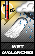
Both natural and human triggered wet avalanches are likely.
Expect localized wet slab avalanches to release from terrain steeper than 35º across all aspects up to at least 4500′. These wet slabs could be up to D3 in size (powerful enough to destroy a vehicle or wood-frame house) and run thousands of feet from steep upper elevation terrain all the way down to flat (and possibly even snow-free) lower elevation terrain near sea level.
Widespread persistent weak layers exist in the Western Chugach snowpack in the form of the very significant January facet layer, as well as basal facets and depth hoar near the ground. Recently, these layers have been subjected to above freezing temperatures and rain day and night. This has lead to very large natural avalanches in recent days due to a loss in snowpack strength. More large to very large natural wet slab avalanches are expected in the coming days.
Expect widespread loose wet avalanches up to D2 in size (large enough to bury, injure, or kill a person) to release from terrain steeper than 35º across all aspects to at least 4500′. These will be the most dangerous where terrains traps and/or exposure increase the consequences. They may also trigger larger and more dangerous wet slabs as they descend.
Rather than digging snowpits and conducting stability tests, wet avalanches are better assessed by being mindful of the snowpack’s level of saturation. Considering days of above freezing temperatures and rain to the upper elevations, wet avalanches will remain likely (and travel conditions inefficient and unpleasant) until the snowpack re-freezes.
Problem 2 – Cornice Fall
![]()
Cornices (especially over typically leeward slopes: primarily west clockwise through north aspects above 3000′) are large and overhanging in many areas of Chugach State Park. Recent warm temperatures and rain have weakened them significantly, making them more prone to falling naturally.
Beware of overhead cornice fall hazard, and the naturally triggered avalanches that may result. If you are up in the alpine, give potentially corniced ridges a wide berth; cornices may break off further back than expected. Do not approach the edge of a snow-covered ridge, unless you’re sure it’s not corniced. A cornice fall itself is dangerous, especially if the human trigger falls onto exposed terrain. Cornice falls may also trigger slab avalanches as they “bomb” the slope they fall onto.
Danger Trend
Increasing.
Mountain Weather
Above freezing temperatures and rain into the upper elevations with light to moderate wind.
Please let us know what you’re seeing by tagging us on Instagram @anchorage_avalanche_center, submitting an observation, sending an email to info@anchorageavalanchecenter.org, or via FaceBook message. All observations help us provide the public with a better forecast product – no matter how basic. We are more than willing to keep observations confidential, and only use the information to inform forecast products.