
Avalanche Danger Forecast
Issued Sunday, December 20, 2020 at 10pm for the greater Anchorage area Western Chugach Mountains (i.e. Chugach State Park):
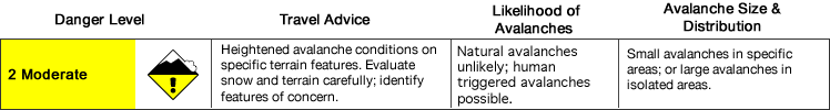
The avalanche danger is expected to start at moderate, but rise to considerable later in the day.
Tuesday: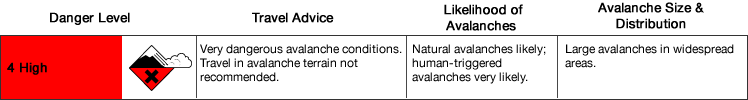
Travel in and around avalanche terrain is not recommended Tuesday. Extremely strong winds are forecast that will drastically increase avalanche danger, and generally make alpine travel unsafe. Rising temperatures and potentially heavy precipitation in some areas will further increase the danger.
Wednesday: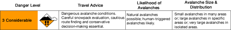
The danger is expected to begin decreasing Wednesday.
__________
Southcentral Alaska is forecast to be impacted by a major storm this week with rising temperatures, extreme winds, and heavy precipitation.
Hurricane-force winds are possible in the alpine of Chugach State Park, as well as heavy snowfall (more likely in southern and eastern zones).
Avalanche Problems:

Widespread natural and human triggered wind slabs up to D3 in size are likely by Tuesday.
Significant wind loading due to extremely strong winds may trigger slabs in the upper elevations that run thousands of feet into lower elevation, and even flat, terrain.
Many popular trails in Chugach State Park (e.g. Indian Creek, Falls Creek, Powerline from Glen Alps, and South Fork Eagle River near Eagle Lake) cross potentially dangerous paths that may run naturally and produce large and destructive avalanches. Beware of steep mountain slopes above you (even if you’re on a flat trail)!
Other trails, like Penguin Ridge from Turnagain Arm, ascend potentially deadly terrain traps for thousands of feet. It’s very possible that the path affecting the Penguin Ridge trail runs naturally during this storm event producing a very large, destructive, and unsurvivable avalanche.
Wind slabs triggered in the upper elevations during this forecast period may “step down” and trigger larger, more dangerous, and potentially very destructive persistent slab avalanches.

Persistent slabs up to D3.5 in size are possible.
Stress from wind loading, snowfall, and rising temperatures is expected to significantly destabilize the snowpack and increase the likelihood of natural and human triggered persistent slabs (that had been relatively dormant prior to the incoming storm).
Diverse and widespread persistent weak layers exist in the snowpack. Faceted snow exists above and below crusts in some areas, sandwiched between wind packed layers in many areas, and a basal weak layer of advanced facets and depth hoar is widespread.
__________
If conditions begin improving Wednesday, it will be very important to approach avalanche terrain with caution. While the likelihood of naturally triggered avalanches (from wind, rain, snow, and warm temperatures) is expected to decrease significantly, human triggered avalanches may remain likely.
Click the hyperlinks and icons to learn more.