
Avalanche Danger Forecast
Issued Friday, February 25, 2021 at noon for the greater Anchorage area Western Chugach Mountains (i.e. Chugach State Park). View map of primary forecast area here.
Friday-Saturday
Sunday:
Increasing danger Friday: strong wind ushering in a storm later Friday that may bring a few to several inches more snow to the alpine will increase the danger to considerable in some areas.
Continuing moderate to strong wind and the chance for more snow Saturday will keep the danger in some areas elevated at considerable, primarily due to further wind loading.
Beware of steep terrain above you where a natural avalanche might occur. It’s possible that a natural avalanche triggered in the upper elevations might run into flatter, lower elevation terrain and cross a trail (e.g. Penguin Ridge and Falls Creek from Turnagain Arm, Powerline from Glen Alps along the north side of the Flattop-Flaketop ridge, Upper South Fork Eagle River near Eagle Lake). Make sure you know how to identify avalanche terrain, and don’t linger under avalanche paths that cross trails.
The danger is expected to decrease Sunday if there’s no significant new snow or wind loading, as the snowpack will have started its adjustment to stress due to the new load from recent snow and wind. Forecast temperatures should also promote bonding and stabilization.
Even with decreasing danger Sunday, remember that 34% of avalanche fatalities occur when the danger is moderate and avalanche conditions are in no way expected to be “safe” on Sunday.
Mountain Weather:
Friday: cloudy with snow developing, alpine temps in the 20s, moderate to strong east to south wind
Saturday: cloudy with a chance of snow, alpine temps in the 20s, moderate to strong southerly wind (decreasing later)
Sunday: decreasing clouds, alpine temps in the teens to 20s, moderate wind (likely west to north)
Discussion:
The mountains received a few to several inches of new snow this week and riding conditions have improved, but still remain variable (as of Wednesday evening).
New snow from this week is dense with relatively high water content. While the higher water content will allow new snow to bond more readily, it’s created more stress on the snowpack and more readily formed into consolidated slabs.
In some places (primarily the most wind-exposed upper elevation locations) new snow had already been stripped away by the wind back to old, firm surfaces by Wednesday afternoon. In other places new snow had been wind loaded into deposits well over a foot thick.
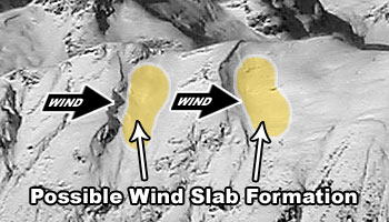
Natural cornice falls and D1 wind slabs that likely occurred late Tuesday or early Wednesday were observed in the upper elevations on west to north aspects Wednesday afternoon.
Skiers triggered wind slabs Wednesday in a cross-loaded gully. These wind slabs were triggered while riding above and along the side of the gully (not in it). Shooting cracks radiated out several feet and initiated avalanches along the corniced and wind loaded sidewall (see photos below). These photos are of a (1F-) wind packed slab up to ~14” on a ~1″ (4F) buried near surface facet weak layer with a (1F) wind-packed bed surface (west aspect ~1900′ HS-ASu-R1-D1-I).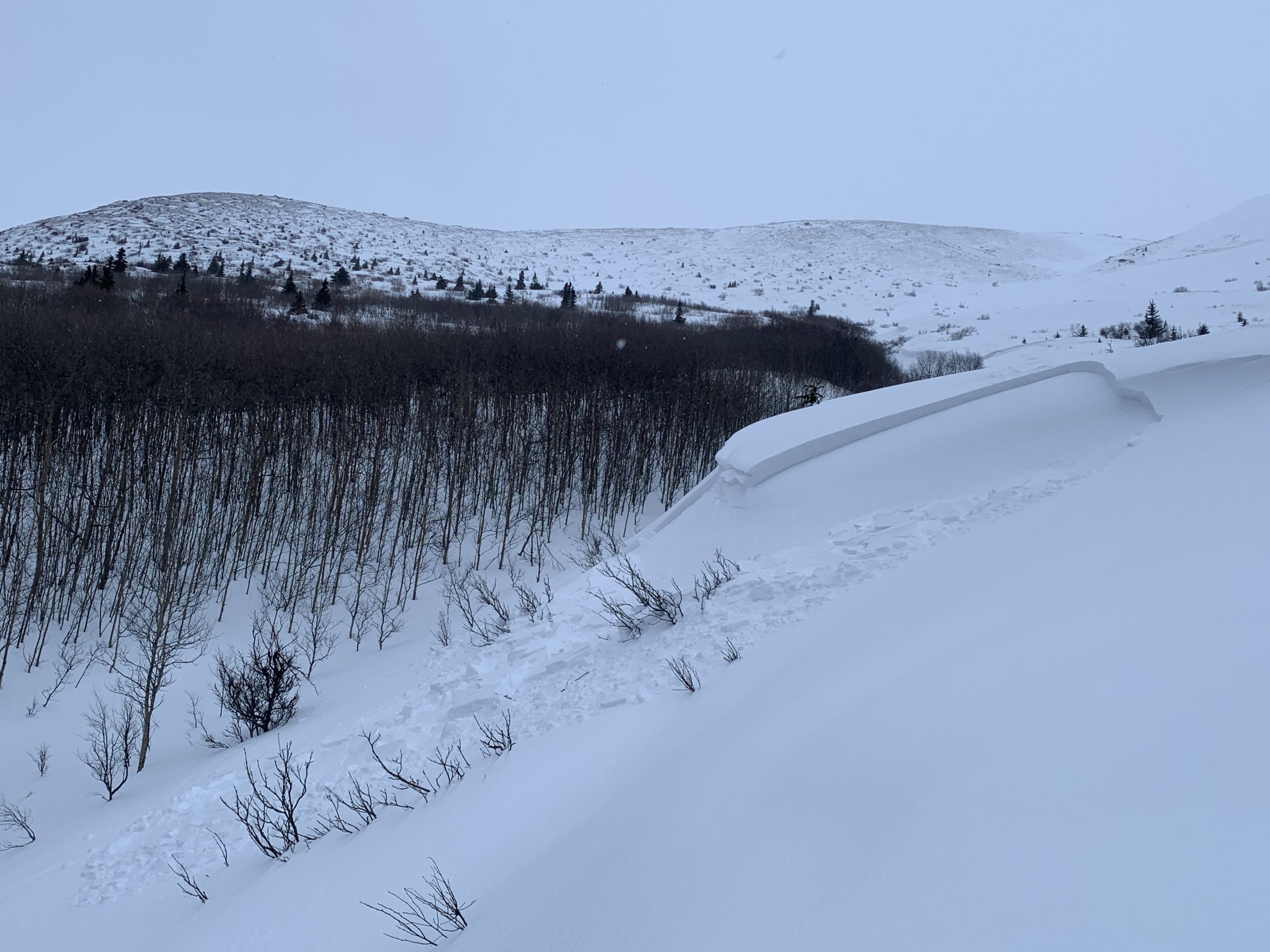
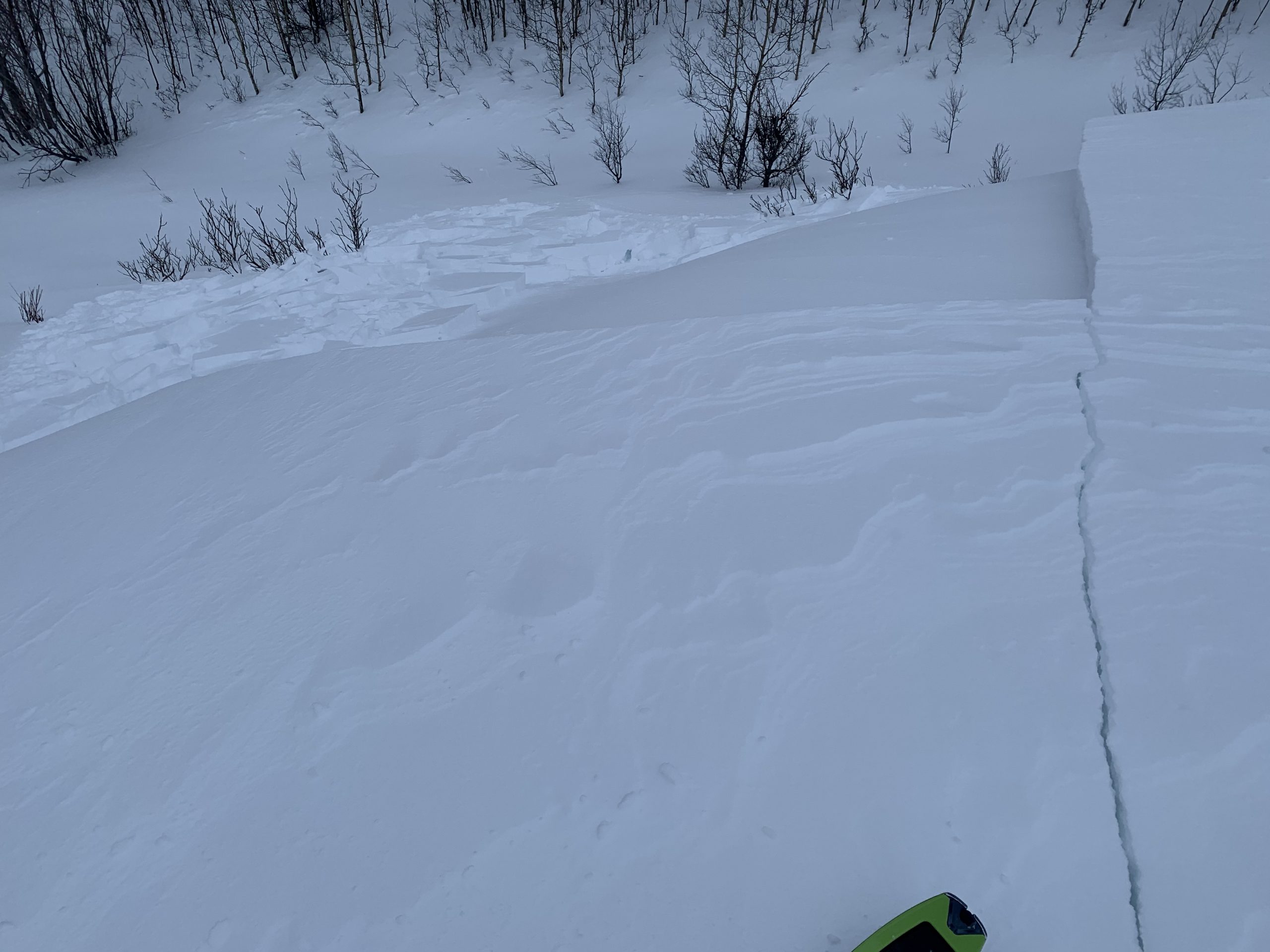
Red flags were present on Wednesday in the South Fork Eagle River area. In addition to the recent natural avalanches as mentioned above, a lot of subtle collapsing (aka “whumphing”) was experienced. We experienced a lot of whumphing on the standard approach to N Bowl above Hunter Pass (fresh wind slab on buried near surface facets) and really worked the terrain to avoid wind loaded areas.
The temperature gradient within the snowpack continues to improve due to more snow and warmer temperatures in recent days that are forecast to continue into the weekend. This is improving the metamorphism and stability of persistent weak layers, especially widespread basal facets. However, deeply buried persistent weak layers have by no means become completely dormant and will be stressed (and more prone to failure) this weekend due to new snow and significant wind loading.
Avalanche Problems:
 Wind slabs up to D2 in size above 2000′ on leeward terrain steeper than 35º.
Moderate to strong wind this forecast period combined with existing loose snow and forecast new snow will significantly load leeward terrain. Winds are forecast to initially be east to south Friday, become more southerly Saturday, and eventually shift to a more westerly orientation. Northerly wind is possible Sunday.
Active wind loading, recent avalanches, and shooting cracks are red flag indicators of wind slab danger. Wind slabs are most likely to exist below corniced areas and along the lee sides of ridges and cross-loaded features like gullies:
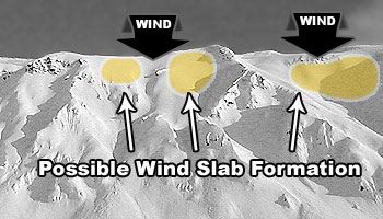
Relatively densely-packed (firm and “punchier” feeling) snow and pockets of deeper snow (especially with a bulbous or fat appearance) are indicators of wind slabs. If you look closely at the snow surface you may be able to distinguish where wind slabs exist due to the snow having a more textured, densely-packed, consolidated, cohesive, and/or striated appearance. Be especially wary of (and avoid) steep, convex, and/or unsupported wind loaded terrain features.
Pole probing and hand pits are a quick and effective means of assessing this problem as you travel. Use pole probing to quickly feel out areas of denser, wind-packed snow overlying looser and weaker snow. Use hand pits to quickly assess how near-surface layers of snow are bonded.
Digging a snowpit and conducting a compression test and/or extended column test will provide an even better assessment of bonding and instability before you travel on terrain of consequence.
You can also assess wind slab instability via safer “test slopes” that are representative of higher consequence terrain.

Persistent slabs up to D2.5 in size above 2000′ on terrain steeper than 35º.
While persistent slabs may exist on all aspects, expect the problem to be the most pronounced on recently wind loaded terrain (where buried persistent weak layers will be stressed and prone to failure) and shadier and colder northerly aspects (where the temperature gradient hasn’t facilitated bonding and stabilization of buried persistent weak layers).
The persistent slab problem is lower probability, but potentially much higher consequence, than the wind slab problem. Persistent slabs triggered this forecast period may be hard slabs that break deeper down in the snowpack and release above and around a human trigger (rather than at the trigger’s feet) which can make escape difficult. Hard slab avalanche debris is also more likely to cause trauma than debris from soft slabs.
Be on the lookout for red flag warnings of persistent slab danger: recent avalanches, collapsing (aka “whumphing“), and shooting cracks.
Diverse and widespread persistent weak layers exist in the snowpack. Faceted snow exists above and below crusts in some areas, sandwiched between wind packed layers in many areas, and a basal weak layer of advanced facets and depth hoar is widespread. Surface hoar may also exist in isolated areas, although dangerous terrain where it’s been buried intact is likely very limited. That said, keep it in mind if you’re traveling around mid elevation terrain traps.
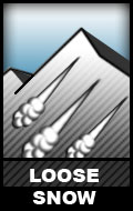 Dry loose snow avalanches (human triggered sluffing and naturally triggered spindrift) are possible above 3000′ on steep terrain (38º+) across all aspects.
While these relatively small avalanches (D1) aren’t much of a concern in regard to burial, they do have the potential to cause a fall or loss of control. While not likely, it’s possible that a loose snow avalanche could trigger a larger wind or persistent slab as it descends a slope.
Don’t let a loose snow avalanche catch you off guard. Manage your sluff if descending (via ski or snowboard) steep and wind-sheltered terrain with loose and uncohesive snow. If it’s windy and you’re climbing steep and/or exposed terrain, be mindful of the potential for heavy spindrift that could knock you off your feet and take you for a (potentially deadly) ride.
![]()
Both natural and human triggered cornice falls are possible. Cornices are large and overhanging in some areas above 2000′. New snow and strong winds this weekend will make them more prone to failure and falling.
Give cornices a wide berth and don’t approach the edge of a ridge to look down slope unless you’re sure it’s not corniced. Cornices can break off further back than expected (even beyond the true edge of the mountain ridge beneath the snow surface). In addition to the danger of taking a nasty fall due to a collapsing cornice, a falling cornice may “bomb” the slope it lands on and trigger an avalanche.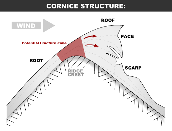
Terrain management is always the best way to deal with avalanche problems: eliminate or reduce your exposure to terrain capable of producing an avalanche. Before traveling on or under terrain that has the potential to avalanche think about the consequences and have a plan (to escape the avalanche, for re-grouping, and rescue).
Always be mindful of terrain traps that can make even a small avalanche deadly.
Click the hyperlinks and icons to learn more.
Please let us know what you’re seeing by tagging us on Instagram @anchorage_avalanche_center, submitting an observation, sending an email to info@anchorageavalanchecenter.org, or via FaceBook message. All observations help us provide a better forecast product (no matter how basic). We can keep your observation confidential, and only use the information to inform forecast products.