
Arctic Valley
Signs of instability:
- Isolated and subtle shooting cracks and whoomphing in wind-loaded areas along ridges (Rendezvous northerly aspects & Gordon Lyon southerly aspects)
Weather:
- Passing low clouds with very light, isolated, and scattered flurries
- Light northerly breeze with moderate gusts by afternoon; enough for some subtle snow transport in the upper elevations while gusting
- Low single digit temperatures
Surface Conditions:
- Average of 10″ loose, unconsolidated, champagne, blower powder (beautiful stellar formations) on top of a mostly smooth and supportable melt-freeze/rain crust (more breakable at elevations below 3000′) where there was prior coverage – bare tundra and rocks under the new snow in many areas
- Little wind-affected snow (soft and subtly wind loaded and affected areas along ridges and cross-loaded terrain features)
Snowpack Discussion:
The wet, melt-freeze conditions from about a week ago combined with more recent cold temperatures helped to stabilize the snowpack prior to this weekend’s snowfall. While the rain and above freezing temps from about a week ago thinned the snow cover in the Front Range and Eagle River area, it helped to heal a very unconsolidated, weak, and faceted snowpack. The cold temperatures prior to this weekend’s storm helped “lock-up” the early season snowpack that had been “cooked down” by above freezing temps and very light rain and, on the bright side, these conditions provided us with a more solid and substantial base. Add to that 10-20″ of new snow and Anchorage’s backyard snowpack is coming along nicely. Let’s hope the forecast calling for minimal wind over the next few days followed by another snow event midweek hold true, and we’ll hopefully have great holiday season skiing in the Anchorage hills.
The new snow seems to be bonding better than expected to the old snow surface. It will still slough off easily in steeper terrain, but doesn’t seem to be stripping all the way down to the iciness. The slow influx of flurries and very light snow over the couple days prior to this weekend’s storm seems to have acted as an adhesive of sorts, between the old, icy, melt-freeze surface and the substantial new snow we’ve received since Friday.
Light and decreasing winds throughout the storm, without much directional change besides the early shift from southerly to northerly, have left us with surface snow that has little to no wind affect. Combine this with relatively consistent and decreasing temperatures throughout the storm and we’ve been gifted with a nice “right-side up” 10-20″ deposit of new snow.
Snowfall totals seem to be the highest along northern Turnagain Arm and the southern Front Range, decreasing to the north. Here’s some nice images and data provided by the Anchorage NWS:
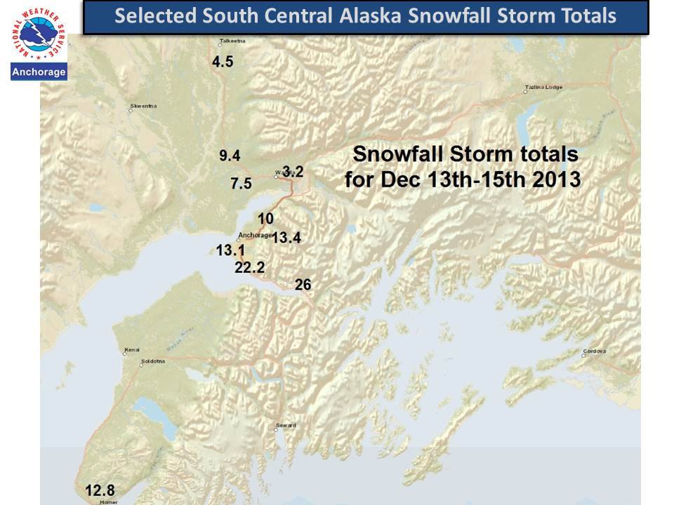
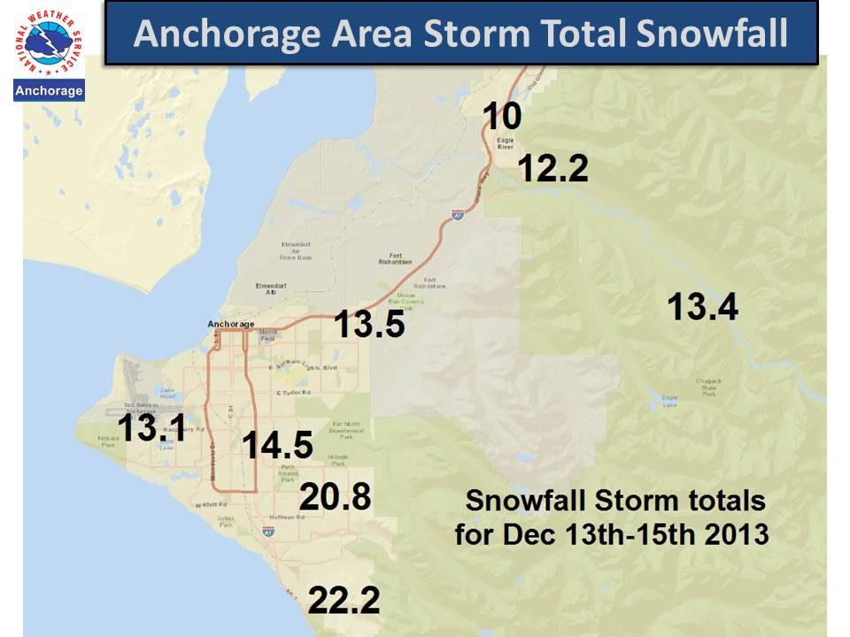
...STORM TOTAL SNOWFALL AMOUNTS AS OF 9 AM...

THE FOLLOWING IS LIST OF STORM TOTAL SNOWFALL AMOUNTS
FROM FRIDAY THE 13TH THROUGH 9 AM AKST THIS MORNING:

LOCATION-----------------------------------AMOUNT

NEAR GIRDWOOD..............................26.0 INCHES
NEAR POTTER MARSH.........................22.2 INCHES
ANCHORAGE HILLSIDE.........................20.8 INCHES
NEAR GLEN ALPS.............................16.0 INCHES
NEAR LAKE OTIS AND 80TH AVE................14.5 INCHES
NORTHEAST ANCHORAGE........................13.5 INCHES
EAGLE RIVER NATURE CENTER..................13.4 INCHES
ANCHORAGE NWS..............................13.1 INCHES
EAGLE RIVER RD NEAR GREENHOUSE ST..........12.2 INCHES
NORTH EAGLE RIVER ACCESS RD EXIT...........10.0 INCHES
WILLOW......................................9.4 INCHES
BIG LAKE....................................7.5 INCHES
TALKEETNA...................................4.5 INCHES
PALMER TRUNK RD AND PALMER WASILLA HWY......3.2 INCHES
PALMER CEDAR HILLS AREA.....................2.4 INCHES
12/15/2013 Arctic Valley observations from Sarah Carter, Alaska Avalanche Information Center Education Director and AIARE Instructor:
1230-1630 Dec.15, 2013 Arctic Valley 2600-3400′
-14C, brief broken skies returned to obscured visibility by 1530, light north wind.
Toured up to saddle between Gordon Lyon and Rendezvous Peak. Average HS 45-60cm. Pf 35cm. 25cm HST, no slab, sticking to early Dec. crust. In places, the melt freeze/facet crust was crumbly with advanced facets to 3mm beneath at the ground. Several CTs produced varied results. The most surprising was a CTV that suddenly collapsed under the crust in facets. The rest were CT11-14 at the HST/MFC interface, resistant planar.