
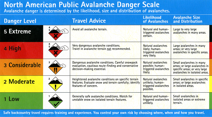
Weekend Avalanche Outlook
This is a regional backcountry avalanche forecast for the Western Chugach Mountains of Chugach State Park. It is provided pro bono by a local avalanche professional, is based on limited field data for a large area, and is meant to be used only as a general baseline for recreationists’ personal and specific assessment in the field. The Anchorage Avalanche Center and associates assume no responsibility or liability for the use of this information. Anyone using this information needs to be formally educated in regard to avalanches and backcountry travel. Please encourage statewide investment in high quality outdoor and environmental education via K-12 public schools, as this is the best way to ensure all Alaskans are “avy savvy.”
Click the hyperlinks and icons for further learning.
Get outside and enjoy The Greatland! This is your weekend avalanche outlook for April 3-5, 2020.
The avalanche danger this weekend is expected to be moderate. Be sure to practice safe travel protocols and effective terrain management to minimize exposure to potentially dangerous avalanche terrain and reduce the consequences if an avalanche is triggered.
A few to several inches of new snow are expected in the alpine of Chugach State Park from snowfall Thursday into Friday. Winds have generally been light and aren’t forecast to increase beyond light-moderate, but beware of fresh wind slab development should winds increase.
Recent weather has generally only contributed to increasing avalanche danger in the form of newly developed near-surface instabilities from the snow event Thursday into Friday. The very serious persistent slab problem we’ve been dealing with for many weeks has generally improved and is not expected to seriously reawaken until temperatures and solar radiation increase significantly causing a loss in snowpack strength and potentially catastrophic failures on the January facet layer and depth hoar and basal facets near the ground.
It’s now the time of year when rockfall is a serious hazard. Where a helmet around steep, rocky terrain and be mindful of rockfall danger as temperature and solar radiation increases.
Problem 1 – Storm Slab
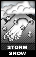
Human triggered storm slabs are possible above 2500′ on terrain steeper than 35º across all aspects. In the upper elevations, which are expected to have received more snow (several inches possibly) from the recent storm, these avalanches could be up to D2 in size (large enough to bury, injure, or kill a person). Be mindful of terrain traps that could cause debris to pile up more deeply, and exposed terrain where a fall or loss of control due to even a small avalanche could lead to significant trauma.
Quick hand pits are an effective means of assessing how the recent snow has bonded to old snow surfaces, which generally consisted of firm to very firm faceted wind-packed snow and crusts. These old snow surfaces are not expected to provide a very cohesive and stable interface with new snow, given the low friction. However, the recent storm was relatively warm and the expected fine-grained particles may bond quickly. As always, do your own assessment of stability in the area in which you’re traveling. If you are determined to ride terrain steep enough to slide, don’t just dive in. Think about consequences, have an escape plan, and use slope cuts and terrain features to your advantage.
Problem 2 – Persistent Slab

Human triggered persistent slab avalanches up to D3 (large, deadly, and destructive) in size are possible above 2500′ on terrain steeper than 35º across all aspects. The persistent slab danger is generally higher in northern areas of Chugach State Park (i.e. from Arctic Valley north to the Knik River), and lower in southern areas of the park (i.e. Front Range and Turnagain Arm).
Persistent slab danger has decreased significantly from prior advisories due to melt-freeze cycles and a more benign spring temperature gradient in the snowpack. However, it remains a lower probability but very high consequence problem.
Steep northerly terrain in the upper elevations is expected to be the most problematic for dangerous persistent slabs. When temperatures warm and solar radiation increases (which may occur Friday afternoon), persistent slabs on solar aspects will destabilize and be more prone to human triggering.
A human triggered persistent slab may be very difficult to escape, as a person may be able to get into the middle of the slab before it releases from above with hard slab characteristics. The hard slab nature of the debris also makes trauma more likely.
The best way to manage the tricky persistent slab avalanche problem is to simply avoid terrain capable of producing a large slab. The most likely terrain to produce such a dangerous avalanche is a big and steep slope that’s convex, unsupported, and/or has thinner areas where the persistent weak layer is closer to the surface and more likely to be impacted by a human trigger.
Assessment this problem in the specific area in which you’re traveling will require thorough snowpack investigation: digging a snowpit, analyzing the stratigraphy, and conducting stability tests like the ECT. As always, be mindful of red flags (especially recent avalanches, collapsing or “whumphing,” shooting cracks, active loading, etc.) and be very diligent about safe travel protocols.
Problem 3 – Loose Snow Avalanches
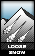
Small human triggered loose dry avalanches (aka “sluffs”) are likely on steep (40º+) terrain above 2500′ across all aspects (especially northerly). Be mindful of the consequences of a fall or loss of control due to a pushy sluff.
Small human and naturally triggered loose wet avalanches are likely on steep (40º+) solar aspects (east, south, and west) if the sun comes out and temperatures warm (as is forecast Friday afternoon). Steep, rocky terrain will readily shed fresh snow as soon as it receives solar radiation. Be mindful of overhead hazards due to natural loose wet avalanches triggered by the sun, even if you’re on flat terrain.
It’s now the time of year when route planning needs to take aspect relative to the sun into consideration. Make sure your route does not expose you to terrain that has been de-stabilized by warm temperatures and solar radiation later in the day.
Loose wet avalanches have the potential to trigger more dangerous slab avalanches as they descend. Warming temperatures and solar radiation may also de-stabilize persistent slabs, as mentioned above.
South and west-facing avalanche terrain and paths in the Turnagain Arm area are prime examples of overhead hazards and terrain traps. Potentially dangerous, sun-exposed avalanche terrain and paths exist in the vicinity of popular hiking trails and nordic ski routes: Penguin Ridge, Bird Ridge, Indian Creek (i.e. Arctic to Indian), and Falls Creek. Make sure you know how to identify and avoid potentially dangerous sun-affected avalanche terrain!
Problem 4 – Cornice Fall
![]()
Cornices (especially over typically leeward slopes: primarily west clockwise through north aspects above 2500′) are large in many areas of Chugach State Park. Cornices are more prone to failure and falling when temperatures warm and solar radiation intensifies. Beware of overhead cornice fall hazard, as well as naturally triggered avalanches that may result from cornice falls.
Give corniced ridges a wide berth; cornices may break off further back than expected. Do not approach the edge of a snow-covered ridge, unless you’re sure it’s not corniced. A cornice fall itself is dangerous, especially if the human trigger falls onto exposed terrain. Cornice falls may also trigger slab avalanches as they “bomb” the slope they fall onto.
Potential Problem – Wind Slab

Small human triggered wind slabs will be possible on steep (35º+) terrain if winds increase. Wind slab danger will primarily be confined to the uppermost elevations along leeward ridges, cross-loaded terrain features, and on the lee side of peaks.
Dangerously wind-loaded snow may feel hollow and punchy, indicating a denser slab overlying looser and weaker snow. It may look pillowy, bulbous, and/or have a smooth, lens-like appearance.
Pole probing and quick hand pits are a way to assess wind slab danger near the surface. Expert skiers and backcountry travelers may be able to use prudent slope cuts to assess and manage the wind slab problem.
Danger Trend
Avalanche danger is expected to increase through Friday from snowfall that ends in the morning followed by clearing skies and increasing solar radiation in the afternoon. Danger is then expected to decrease Friday night into Saturday. Saturday through Sunday danger may again increase with any wind, significantly warming temperatures, solar radiation, and/or new snow.
Mountain Weather
Light snow and cloudy skies Friday morning, clearing later in the day. Cloudy with a chance of snow Saturday and Sunday. Light to moderate winds. Alpine temperatures in the 20s.
Best wishes for your weekend!
Please let us know what you’re seeing by tagging us on Instagram @anchorage_avalanche_center, submitting an observation, sending an email to info@anchorageavalanchecenter.org, or via FaceBook message. All observations help us provide the public with a better forecast product – no matter how basic. We are more than willing to keep observations confidential, and only use the information to inform forecast products.
Funding and resources for this forecast generously provided by the Post-Capitalists and Libertarian Socialists of Alaska who encourage you to #FeelTheBern, #DumpTrump, #RecallDunleavy, and tell Murkowski, Young, and Sullivan that this is their last term! Our democracy and planet are at stake, stand up and fight the power!