
Avalanche Danger Forecast
Issued Monday, January 11, 2021 at 9pm for the greater Anchorage area Western Chugach Mountains (i.e. Chugach State Park). View map of primary forecast area here.
Tuesday-Thursday: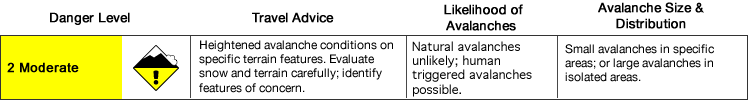
Avalanche danger is expected to stay at a steady moderate through this forecast period.
Avalanche danger is expected to be higher in eastern (deeper in the mountains) and southern (closer to Turnagain Arm) areas of the park due to these areas having received more precipitation recently (several inches of new snow in the past 24 hours).
Other areas of the park (including the primary forecast area) have seen a steady trickle of new snow in recent days, but no significant accumulation. Nearly constant moderate to strong winds, capable of loading leeward terrain, have affected most upper elevation areas of the park for the past several days.
Surface snow conditions remain highly variable and generally hardpacked at the upper elevations, although some deposition/catchment areas hold soft snow. Observers have recently reported quite the mixed bag. In western areas of the park that are more easily accessible observers have found wild sastrugi, “slide-for-life”, breakable windboard, smooth and supportable windboard, as well as powder on a firm base in catchment areas. In eastern and southern areas of the park that are more difficult to access and have higher consequence terrain observers have found deep powder with heavy sluffing and reactive soft slabs.
Avalanche Problems:
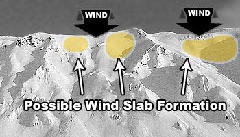
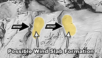
 Wind slabs up to D2 in size are possible above 2500′ on leeward terrain steeper than 35º.
Recent moderate to strong upper elevations winds combined with varying amounts of new snow have created fresh wind slabs that may be reactive to human triggers. Expect such wind slabs to be larger and more dangerous in eastern and southern areas of the park, as well as on higher elevation leeward terrain.
While wind slabs are generally expected to be small and more of a hazard in regard to causing a fall or loss of control rather than burial, be mindful of terrains traps that could greatly increase the consequences of even a small and otherwise insignificant avalanche.
Active wind loading, recent natural avalanches, and shooting cracks are red flag indicators of wind slab danger. Hollow and/or punchy feeling snow (denser, wind-packed snow overlying looser and less cohesive snow) and pockets of deeper snow with a bulbous or fat appearance are further kinesthetic and visual indicators of potential wind slab danger.
Pole probing and hand pits are a quick and effective means of assessing this problem as you travel. Use pole probing to quickly feel out areas of denser, wind-packed snow overlying looser and weaker snow. Use hand pits to quickly assess how near-surface layers of snow are bonded.
Digging a snowpit and conducting a compression test and/or extended column test will provide an even better assessment of bonding and instability before you travel on terrain of consequence.
You can also assess wind slab instability via safer “test slopes” that are representative of higher consequence terrain.
Wind slabs are most likely to exist below corniced areas and along the lee sides of ridges and cross-loaded features like gullies:

Persistent slabs up to D2.5 in size are possible on all aspects above 2500′ where the terrain is steeper than 35º.
This is a low probability, but potentially high consequence, avalanche problem. While predominantly dormant these persistent slabs are unpredictable, and recent snowfall and wind loading may make them more susceptible to human triggering in some areas.
Such hard slabs have a tendency to release above and around a human trigger, rather than at the trigger’s feet, which can make escape difficult. In addition, hard slab avalanche debris is more likely to cause trauma than debris from soft snow.
Diverse and widespread persistent weak layers exist in the snowpack. Faceted snow exists above and below crusts in some areas, sandwiched between wind packed layers in many areas, and a basal weak layer of advanced facets and depth hoar is widespread.
As always, be on the lookout for red flag warnings of avalanche danger. Collapsing (aka “whumphing“) and shooting cracks would be the most likely, although red flags are not expected to be indicators of persistent slab danger this forecast period. Understanding the snowpack where you intend to travel will require more in-depth analysis in the next few days: digging snowpits, conducting instability tests, and analyzing snowpack stratigraphy (layering).
Terrain management is simply the best way to avoid tricky avalanche problems: don’t expose yourself to terrain capable of producing a large and dangerous hard slab.
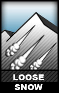 Dry, loose snow avalanches (aka “sluffs) are possible above 3000′ on steep (38º+) and wind-sheltered terrain.
While these (D1) sluffs aren’t much of a concern in regard to burial, they do have the potential to cause a fall or loss of control.
Don’t let a loose snow avalanche catch you off guard. Manage your sluff if descending steep terrain via ski or snowboard. Be mindful of heavy spindrift if climbing steep and/or exposed terrain.
Before traveling on or under terrain that has the potential to avalanche think about the consequences, and have a plan (to escape the avalanche, for re-grouping, and rescue).
Keep in mind that short days with a lot of darkness this time of year increase the difficulty of mountain travel and the consequences of an accident.
Click the hyperlinks and icons to learn more.