
Avalanche Danger Forecast
Issued Saturday, December 26, 2020 at 9pm for the greater Anchorage area Western Chugach Mountains (i.e. Chugach State Park):
Sunday-Monday: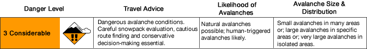
Avalanche danger is expected to increase to considerable Sunday due to extreme winds. Dangerous avalanche conditions are expected to exist through at least Monday.
Extremely strong winds are forecast to impact Turnagain Arm and the higher terrain of the greater Anchorage area beginning Sunday afternoon. In addition to significantly increasing avalanche danger, this will also make travel more difficult and dangerous in general (both in the mountains and on trails and roads in these areas).
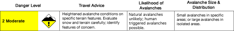
If there is no strong wind or significant snowfall Monday night and Tuesday, avalanche danger is expected to decrease to moderate. However, it will still be important to approach the mountains with caution as human triggered wind and persistent slab avalanches will remain possible.
Many popular trails in Chugach State Park (e.g. Indian Creek, Falls Creek, Powerline from Glen Alps, and South Fork Eagle River near Eagle Lake) cross potentially dangerous avalanche paths that may run naturally during the Sunday-Monday windstorm. Beware of steep mountain slopes above you (even if you’re on a flat trail).
Other trails, like Penguin Ridge from Turnagain Arm, ascend potentially deadly terrain traps for thousands of feet. It’s possible that the path affecting the Penguin Ridge trail runs naturally during the windstorm.
Avalanche Problems:

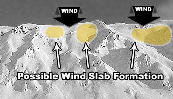
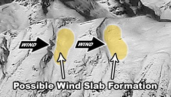
Wind slabs up to D2 in size are likely on leeward terrain above 2500′ through the forecast period. Wind slab danger is expected to be the highest Sunday afternoon through Monday and naturally triggered wind slabs are possible.
Wind slabs are most likely to exist below corniced areas and along the lee sides of ridges and cross-loaded features like gullies:
Active wind loading, recent natural avalanches, and shooting cracks are red flag indicators of wind slab danger. Hollow and/or punchy feeling snow (denser, wind-packed snow overlying looser and less cohesive snow) and pockets of deeper snow with a bulbous or fat appearance are further kinesthetic and visual indicators of potential wind slab danger.
Pole probing and hand pits are a quick and effective means of assessing this problem as you travel. Use pole probing to quickly feel out areas of denser, wind-packed snow overlying looser and weaker snow. Use hand pits to quickly assess how near-surface layers of snow are bonded.
Digging a snowpit and conducting a compression test and/or extended column test will provide an even better assessment of bonding and instability before you travel on terrain of consequence.
You can also assess wind slab instability via safer “test slopes” that are representative of higher consequence terrain.
Wind slabs triggered in big avalanche paths do have the potential to “step down” and trigger larger and more dangerous persistent slab avalanches.

Persistent slabs up to D2.5 in size are possible through the forecast period on all aspects above 2500′. Persistent slab danger is expected to be the highest on upper elevation leeward terrain Sunday afternoon through Monday, as wind loading will add stress and potentially trigger wind slabs that step down to more deeply buried persistent weak layers. While lower probability than wind slabs, persistent slabs are relatively unpredictable and have the potential to be high consequence (due to hard slab characteristics).
Diverse and widespread persistent weak layers exist in the snowpack. Faceted snow exists above and below crusts in some areas, sandwiched between wind packed layers in many areas, and a basal weak layer of advanced facets and depth hoar is widespread.
Recent natural avalanches, collapsing (aka “whumphing“), and shooting cracks are red flag warnings of persistent slab danger.
Without red flags, which will become less likely with time, understanding how this problem is manifesting where you intend to travel will require digging a snowpit, conducting instability tests, and analyzing snowpack stratigraphy.
Terrain management is simply the best way to avoid this avalanche problem: don’t expose yourself to terrain capable of producing a dangerous persistent slab.
Before traveling on or under terrain that has the potential to avalanche think about the consequences, and have a plan (to escape the avalanche, for re-grouping, and rescue).
Be mindful of terrains traps!
Keep in mind that short days with a lot of darkness, poor visibility, and inclement weather this time of year increase the difficulty of mountain travel and the consequences of an accident.
Click the hyperlinks and icons to learn more.